
SIM Location Tracker · Airtel · Jio · Vi · Works Without GPS · TRAI Compliant
SIM location tracker — works where GPS stops. No hardware. No app.
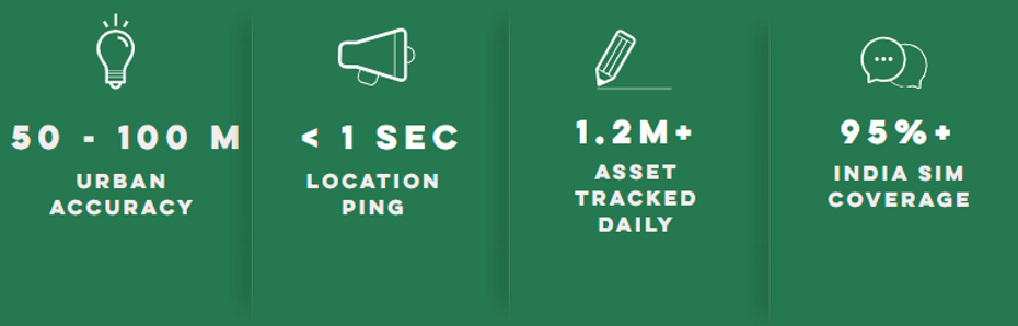
GPS fails in tunnels, basements, and rural dead zones. SIM location tracking uses India's cellular network to track any vehicle, agent, or asset — in real time, without a device, without an app. Trusted by 188+ enterprises across India.
20+ Fortune 500 · 6 industries
Accuracy — The Honest Answer
The Question every Operations Manager asks
"How accurate is your location?" is the first question Dotmove hears on every enterprise sales call. It is the right question to ask. And it deserves a straight answer — not a marketing claim.
The honest answer is that SIM location accuracy depends on the network signal source available at the time of the query. Here is exactly what Dotmove delivers in each scenario:
Where GPS Fails — SIM Tracking Works
Two scenarios that happen every day in Indian logistics .Why GPS cannot handle them?
GPS tracking is marketed as the gold standard. For outdoor, open-sky environments it is. But Indian logistics does not operate in ideal conditions. Two of the most common failure points — tunnels and basement loading bays — are locations where GPS fails completely and SIM location tracking continues working without interruption.
GPS fails here
Long-haul vehicles crossing highway tunnels
India's expanding highway network includes tunnels on NH-44, NH-3, and multiple mountain passes used daily by long-haul freight. GPS devices lose satellite signal entirely inside tunnels — sometimes for 10–20 minutes. Dispatchers see the vehicle disappear from the map and have no visibility until it emerges on the other side.
GPS result: Vehicle goes dark. Dispatcher has no visibility. ETA calculation breaks.
SIM tracking works here
Long-haul vehicles crossing highway tunnels
Cellular towers positioned near tunnel entrances and exits maintain network connectivity for SIM-equipped devices throughout transit. Dotmove's SIM location tracker continues returning location data — based on the last confirmed cell tower — keeping dispatcher visibility intact throughout the tunnel crossing.
SIM result: Continuous location visibility. Dispatcher sees vehicle progress. ETA stays accurate.
GPS fails here
Vehicles offloading material in basement facilities
Delivery trucks, material transport vehicles, and service fleets regularly enter basement loading bays — large retail distribution centres, manufacturing facilities, and commercial complexes. Underground structures block GPS satellite signals completely. The vehicle disappears from tracking the moment it enters the basement.
GPS result: Vehicle untracked for duration of basement dwell. Proof of delivery unverifiable.
SIM tracking works here
Vehicles offloading material in basement facilities
Cellular signals penetrate building structures that block satellite signals. SIM location tracking continues to function in basement facilities, confirming vehicle presence on-site even without GPS line-of-sight. Proof of arrival and departure is maintained throughout the basement dwell period.
SIM result: Vehicle tracked on-site. Arrival confirmed. Departure verified. Proof of delivery intact.
How It Works
The technology behind SIM location tracking
SIM location tracking works by querying the cellular network — not satellites. Every mobile device with an active SIM is constantly connected to the nearest cell towers. Dotmove's platform uses this existing network infrastructure to determine location without requiring any hardware or software on the tracked device.
SIM connects to cell towers
Every active SIM card is registered with the nearest cell towers of its operator — Airtel, Jio, or Vi. This happens automatically, continuously, without any action from the device user.
No APP Needed
Dotmove queries the operator
When your system calls the Dotmove Location API with a mobile number, Dotmove queries the subscriber's registered operator. The operator returns cell tower data for that SIM's current connection.
< 1 sec Response
Location coordinates returned
Dotmove processes the cell tower data using triangulation — calculating position from the signal strength and timing of multiple towers — and returns a latitude/longitude coordinate with an accuracy radius to your system.
JSON RESPONSE
SIM Location vs GPS Tracking
Choosing the right tracking technology for Indian operations
Neither SIM location tracking nor GPS is universally superior. The right choice depends on your fleet type, operational environment, and infrastructure constraints. Here is the honest comparison.
Factor | Sim Location Tracker | GPS Device Tracking |
|---|---|---|
Works on feature phones | ✓ Any phone with active SIM | ✓ Any phone with active SIM |
Capex required | ✓ Zero — per MSISDN licence | ✗ ₹3,000–4,000 per device |
Deployment time | ✓ 3–7 days via API | ✗ Weeks of hardware installation |
Rural accuracy | 200m – 1 km | 3–10m outdoors with clear sky |
Urban accuracy | 5–150m depending on signal source | 3–10m outdoors with clear sky |
Works on third-party vehicles | ✓ Any Indian SIM | ✗ Device must be installed |
Works in basements | ✓ Cellular penetrates structures | ✗ Satellite signal blocked |
Works in tunnels | ✓ Cellular signal maintained | ✗ No satellite line-of-sight |
Hardware required | ✓ None — uses driver's SIM | ✗ GPS device per vehicle |

RELATED SOLUTIONS
Go deeper on specific capabilities
MSISDN TRACKER
How SIM-based tracking works without GPS - coverage, accuracy, and limitations for operations team, you should know
SIM-BASED TRACKING INDIA
Complete guide to SIM tracking deployment across Indian Telecom networks and enterprise roll out strategy
Phone TRACKING API
The only phone tracking API in India with compliance built in — RC, DL, E-Way Bill and FASTAG on the same platform.
SIM NUMBER TRACKER
API documentation and integration guide for tracking any India phone number via cellular network real time