
Centimeter-Level Location Accuracy


123-456-7890
Our high precision GNSS receiver Android application delivers 2–3 cm centimeter level accuracy, converting standard Android smartphones into survey grade positioning tools. Powered by multi constellation GNSS, dual frequency satellite signals, and real time RTK corrections, the app provides reliable, verifiable, and professional grade location data without the need for expensive GPS equipment.
Built for real time and mission critical field operations, the solution integrates GNSS INS, ensuring stable positioning during motion, signal obstruction, or brief satellite interruptions. This allows consistent performance in demanding outdoor, urban, and semi open environments where accuracy cannot be compromised.
The platform is fully compatible with enterprise grade hardware such as XRED3000GNSS, enabling seamless integration for advanced industrial and professional workflows. Whether deployed as a standalone mobile GNSS receiver or paired with external devices, the app ensures precision, reliability, and scalability.
Designed for industries including land surveying, construction and infrastructure development, GIS data collection, smart city mapping, utilities and power networks, telecom planning, precision agriculture, mining operations, drone ground control, disaster management, and public safety, the solution also supports advanced satnav based positioning for dependable real-time results.
By combining portability, enterprise grade accuracy, and real-time performance, this GNSS Android application offers a cost effective and future ready solution for professionals who demand precision in every location fix.
Precision Powered by Advanced GNSS

The app leverages:
-
Multi-constellation GNSS (GPS, GLONASS, Galileo, BeiDou*)
-
Dual-frequency support (L1 + L5) on compatible Android devices
-
RTK (Real-Time Kinematic) corrections
-
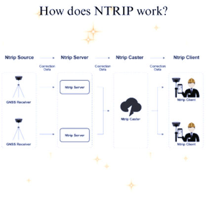
NTRIP client integration for real-time correction streams
By applying carrier-phase corrections instead of standard code-based positioning, the app achieves survey-grade accuracy in real time.
*Constellation availability depends on device chipset and region.
Key features

-
2–3 cm horizontal accuracy in real-time
-
Android-native GNSS processing (no external receiver required on supported devices)
-
RTK & NTRIP server compatibility
-
Live accuracy indicators (Fix / Float / DGPS)
-
Low-latency positioning updates
-
Coordinate export (WGS84, local CRS)
-
Secure data handling & encrypted communication
-
Works in outdoor and semi-open environments
Key Difference
Features | Standard GPS App | Premium GNSS App |
|---|---|---|
Enterprise Ready | No | Yes |
Real-Time Precision | No | Yes |
Professional Use | Limited | Survey Grade |
Correction Data | None | RTK / NTRIP |
Accuracy | 5 -10 mts | 2 -3 cms |
Business Applications
Infrastructure, Surveying & Construction
-
Land surveying and boundary mapping
-
Construction site layout, alignment, and staking
-
Road, rail, and bridge construction monitoring
-
Utility and underground asset mapping
-
Telecom tower planning and network rollout
Workforce Tracking & Field Operations
-
Real-time workforce tracking for field employees
-
Attendance and geofencing for on-site staff
-
Field engineer and technician movement monitoring
-
Lone worker safety and emergency location
-
Productivity analysis for mobile workforce teams
Healthcare & Social Services
-
Mobile healthcare unit tracking
-
Home-care workforce monitoring
-
Emergency medical response coordination
Logistics, Fleet & Transportation
-
Fleet and vehicle tracking with high accuracy
-
Route optimization and navigation
-
Yard and warehouse vehicle movement tracking
-
Port, airport, and container terminal operations
-
Rail and metro asset positioning
Smart Cities & Urban Planning
-
Smart city GIS data collection
-
Digital twin creation and urban mapping
-
Traffic monitoring and congestion analysis
-
Public transport tracking and optimization
-
Street asset inventory (lights, signage, utilities)
Emergency, Government & Public Safety
-
Disaster response and rescue operations
-
Emergency vehicle and responder tracking
-
Law enforcement and investigation support
-
Border and coastal monitoring
-
Search and rescue operations